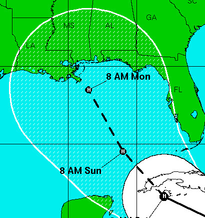
Gustav is set to enter the Gulf this weekend. He’s only a tropical storm right now, but he should be a hurricane by then.
I only became aware of Gustav yesterday, when Karen asked, “When do we start freaking out?” My reply: “Thursday morning.” It’s only Wednesday now, so I’m not worried yet. But I am keeping a close eye on the NHC website.
Yeah, yeah, the track looks like it’s pointed right at New Orleans. But that estimate is five days out, very unreliable. Furthermore, I believe the center of the track is just the area of greatest probability. Gustav could end up anywhere within that cone, which covers half the Gulf. This most recent estimate veers eastward, which is good for us — not so good for those to the east, obviously.
I’ve even learned some misguided Democrats are rooting for Gustav to make a direct hit on New Orleans next week because it will make the Republican National Convention look bad. Fortunately I don’t believe any amount of wishful thinking will influence the weather. Otherwise I’d feel guilty about wishing Gustav off to the east.
Not to worry. Not yet. But this is a good time to check plans and supplies, to make sure everything is prepared.
Update: Come to think of it, I believe the track is constructed from multiple different predictive models, so the center of the track may actually be the area of least probability. My man Bob Breck seems to think so: “I want New Orleans to be the bulls eye at 5 days because it won’t come here…it will be on either side of the center line track by a large distance.” He may be a global warming denier, but he’s still a damn good weatherman.
Later that evening: The University just announced campus will be closed from Friday afternoon until the following Thursday. Kudos to the administration for playing it smart. This makes it easier for students, faculty and staff to evacuate if necessary.
Discover more from b.rox
Subscribe to get the latest posts sent to your email.

We’ll be watching too, Bart. Keep safe.
My God, I can’t believe anyone would actually wish that! That is heinous. Rest assured, that ‘cane making landfall anywhere in the continental US during the RNC, on the anniversary of Katrina, is bad news for the rethugs anywhere it goes.
Bad memories come back this time of year anyway. Probably a good time to start getting real about the possibility.
Come stay with us, we’d love to have you all.
Bob is my guide..because he is a last minute freaker outer. I would like to be about 12 hours ahead of Bob’s freaking out.
You need to see or read this, living in Mid-City and being directly affected:
http://www.wwltv.com/topstories/stories/wwl082708cbrepairs.19db14b8.html
I do not trust the assurance of the SWB on this sudden repair. Also remember that even a sideswipe of the storm could mean flooding if the gates are closed, and with your young daughter and no access to shops or supplies, it might be time for a holiday.
fingers crossed that Gustav doesn’t hit NO- the weather is lovely in b-town right now if you need a vaca here 🙂
peace-
I find it fascinating how many *trained meteorologists* don’t believe in man-made global warming. I guess people with no formal education in the matter are the ones who are better to judge…
Garvey, as a person with “no formal education in the matter” I find it fascinating how many scientists *do* believe in global warming.
I’m not familiar with the NHC site and I was trying to figure out how to get an estimate of wind speed when the storm hits – seems like a head-on run on New Orleans would not be a big deal if it was at a slow speed by then. But that table of wind speeds seems contradictory to the speed probability graphics. Like the first graphic shows that it’s a 5% chance of being hurricane speed, but the chart shows a 40% possibility of being within hurricane range. Which one is correct?
From the chart, it looks like the most probable at 22% is tropical storm, then 20% at dissipation and 17% at cat 1. Is that correct? Just trying to wrap my head around how that works.
Either way, probably a good time to fill up the tank before the media frenzy drives up prices at the pump another buck.
Aw hell, Jon, I don’t know. The only charts I generally look at are the 3 and 5 day cones. And storm surge is the biggest concern for us here, much more than wind speed I’d say.
Just heard about this storm on the radio – thinking of NO in general and you in particular. Stay safe.
Bob Breck haunts my bad dreams…